The Five Ponds Wilderness Area includes 1,064 acres of private holdings, 99 bodies of water covering 1,964 acres, 57.9 miles of trails, and 14 lean-tos. The area is bounded on the north by Cranberry Lake; on the east by the Colton town line and private lands in the vicinity of Gull Lake; on the south by Stillwater Reservoir; on the southwest by the Pepperbox Wilderness Area and on the west by private lands and the Aldrich Pond Wild Forest.
The terrain is low, rolling and interspersed with many small ponds. Swamp areas and small brooks are numerous. The forest cover varies from pole-size hardwoods in the sections that were heavily logged and burned more than forty years ago to virgin pine and spruce stands.
The Five Ponds area is accessible to the public from the north and also from Stillwater Reservoir in the south if one has a boat or canoe, from the east from the Lake Lila Primitive Area and along the Remsen to Lake Placid railroad. The area can also be reached from the southwest via the Raven Lake primitive corridor, and from the east, by boat or canoe, via the Bog River/ Low’s Lake tract. The western boundary in Herkimer County is accessible from the Bear Pond Road in the Aldrich Pond Wild Forest.
We accessed the Five Ponds area of the Adirondacks via Stillwater Reservoir launching from the public boat site.

We paddled across Stillwater Reservoir into Kettle Hole Bay. Kettle Hole Bay is protected from the wind and filled with rocks that prohibit motor boat traffic.

Single portaging the Wenonah MN II with a light backpack up the trail past Kettlehole falls.


The trail intersects with Raven Lake Road. Raven Lake Road is a well-maintained private dirt road leading to an inholding on Raven Lake. West of the road lies the Pepperbox Wilderness, while to the east is the southern portion of the Five Ponds Wilderness. We followed the road until it intersected with Slim Pond. A quick paddle leads one to a narrow channel accessing Raven Lake. Raven is a large delta shaped lake over a half mile across. On the small private in holding stands a well maintained two-story dark green camp befitting its natural surroundings.
We headed north across Raven Lake and found an old trail leading to Lyons Pond. The .6-mile carry to Lyon Lake was well marked with yellow canoe carry disks but appears to get very little use. A double beaver dam marked the end of Lyons Pond. Lyons Pond was crystal clear water with an eery light blue/green color to it. No frogs, salamanders or even bird songs told us this was the effect of acid rains.

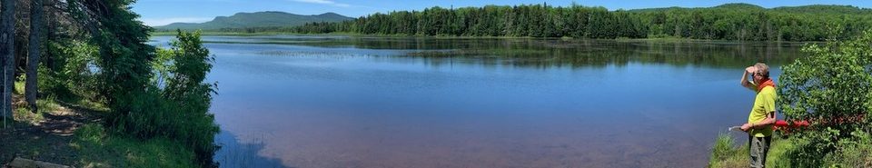
Looking north from the launch point on Lyons Lake.

We found a campsite along the west shore of Lyons Lake and left our backpacks.

We continued north with the empty canoe to Bear Pond. Only a portion of the southern shore of Bear is state owned, the rest is in private ownership. There are two hunting camps on the northern side. Access to these camps is from a jeep road from the north. Diana Pond is only a stones throw from Bear. A dot on the topographic map indicated a previous structure but all that remains was the rusted steel of its roof and a trash dump. Huckleberry Pond appears to be an easy carry to the southeast of Diana, we looked for signs of a trail between Diana and Huckleberry ponds, but found nothing definitive.

We returned back to Lyons Pond where we took a swim. Dinner that night involved experimenting with making chocolate pudding in a ziploc bag, but either we didn’t let it set long enough or the water wasn’t cold enough – it was a little “syrupy”.