Little Tupper Lake is located between Tupper Lake and Long Lake in the William C. Whitney Wilderness Area. Little Tupper is one of the largest motor-less lakes in the Adirondacks. Camping on the lake is first come, first serve. Little Tupper Lake has one access point located on the northern shore. Lake Lila is a large motor-less lake west of Little Tupper Lake. The access point is on the northeastern shore and involves a short carry to the water. Lake Lila offers first come, first serve camp sites.
Matt & Mark joined Kathryn & Jim as we pond hopped from Little Tupper to Lake Lila – involving four significant portages. We planned a trip to Lake Lila via Rock Pond, Hardigan Pond, Salmon Lake Outlet, Lilypad Pond, and Shingle Shanty Brook. It has been done, but not by many.
We crossed a lot of beaver dams, ate lots of blueberries, saw lots of bear scat, and had a good sense of back country.


We used a 18.5′ Kevlar Wenonah Minnesota II and a 18′ fiberglass Sundowner canoe for our trip.

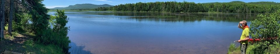
Due to it’s orientation and shallow depths Little Tupper Lake can develop rolling waves so we planned an early start. We dropped the canoes and gear at Little Tupper Lake. Matt and Kathryn loaded up the canoes while Jim and Mark accomplished the car shuttle leaving a vehicle at our Lake Lila takeout. We were on the water paddling by 9am. Below Matt and Mark set off across Little Tupper Lake.
Little Tupper Lake has several islands. The biggest is named Short Island. Not long after Short Island there is a small island with two tall pines growing on either side of a prominent boulder. The Rock Pond outlet is just beyond this islet. Below Jim and Kathryn enter the outlet to Rock Pond.


We encountered and crossed a lot of beaver dams. While some could be breached with a full head of steam and creative use of the paddles and scooting. Others required an exit from the canoe and hauling the loaded boat over the dam.


Paddling up the outlet you encounter a fork about a half-hour up the channel and bear left. There is a beaver dam shortly before the short carry around small rapids and across an old logging road.
Below Jim and Kathryn celebrate crossing one of many beaver dams. Kathryn demonstrated her “Teva Drip” technique trying to minimize the amount of mud and water brought into the canoe.


We reached Rock Pond in short order – just in time to have an early lunch. Jim and Kathryn enjoy lunch break on a rock at Rock Pond while Matt looks askance at someone who might take his crackers.


The carry from Rock Pond to Hardigan Pond is 1.75 miles. The trail begins in a wet section near small knoll on the northwest end of Rock Pond’s western bay. Although there’s no sign, the start is indicated by surveyor’s tape tied to tree branches. The same technique is used to mark the other carries. Kathryn enjoys a quick swim before we set out again.


The portage trail to Hardigan Pond follows an old logging road and intersects several other old roads on the way to Hardigan Pond. At each turn, follow the tape. Shortly before Hardigan Pond there is an intersection with the hiking trail which traverses 8 miles from Sabattis Road. There is a trail marker indicating the hiking trail. Turning left here follows another logging road and a few hundred feet after the turn there is a flagged cairn on the right. Turn here to follow an old railroad bed to the southern shore of Hardigan.
Hardigan Pond is a short ten minute paddle. The Hardigan outlet is quite wide but seems to stop abruptly at a beaver dam. Left of the dam is a mud hole marking the start of a half-mile carry trail to the Salmon Lake outlet. Despite Mark warning me of the deep hole, I found it anyway, sunk in to my knee and almost lost my sandal in the mud. Fortunately, the trail soon reaches dry ground. A few hundred yards from the start, it turns right and eventually reaches the put-in on the Salmon Lake outlet in .4 miles. Salmon Lake outlet is a pretty small flowing stream. Just upstream from the put in there is a small refreshing waterfall.
Arriving at Little Salmon Lake, we checked out the campsite on the lake and decided that the campsite across from the mouth of Salmon Lake Outlet was more to our liking. We saw a medium size bear track in the mud in the outlet.
The blueberries were ripe and everywhere, as were the deer flies. While Kathryn grazed on blueberries, Matt read an SI article about Lance Armstrong, and Mark donned a dryer static sheet to ward off the deer flies.


Kathryn made Spanish Rice for dinner – yummy. Kathryn and Jim squeezed into their little two person Eureka tent and endured a hot evening. The next day we portaged the .45 miles to Lilypad Pond and crossed the pond.


From Lilypad Pond we portaged .85 miles to Shingle Shanty Brook. Below Kathryn and Jim launch their boat at the cable marking the claim to posting Shingle Shanty Brook. Friends of Thayer Lake owns the land, while the Brandreth Park Association owns the recreational rights. Matt, Mark and Jim look relieved to have completed the last portage.


Shingle Shanty Brook is a coy little brook twisting back and forth as it seeks Lake Lila.


Matt and Mark conquer a big beaver dam.


Finally, Lake Lila.


We had lunch on a vacated campsite on Lake Lila. While we were hanging out there we were approached by a DEC Ranger who said he was the last to make the trip (on July 4th) and he estimated less than 100 people had made the trip.

