Thursday Eric finished his 1st year of pre-school at Little Acorn. Attendance was 9:30 – 12:30 on Tuesdays & Thursdays. They held a picnic at the Trenton Town Park with lots of play time toys.
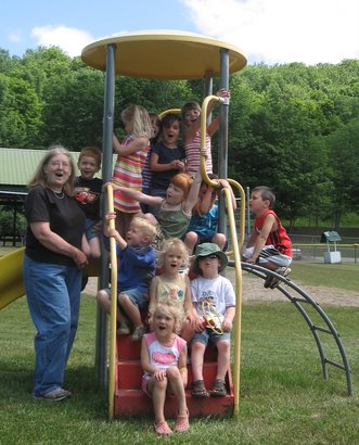

Thursday Eric finished his 1st year of pre-school at Little Acorn. Attendance was 9:30 – 12:30 on Tuesdays & Thursdays. They held a picnic at the Trenton Town Park with lots of play time toys.
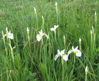
We have some pure white wild iris out in the pasture. They are not fully in bloom yet, but coming on strong. That is the positive aspect to walking down in the pasture. The negative is the goose poop left by the 3 families of geese that moved to the little pond.
Saturday Kathryn and Eric were on their way to check out a garage sale and they discovered a male wood turtle crossing the road about ½ mile from our house. Kathryn recovered the turtle, we took some pictures, and we relocated the turtle to a woodland stream environment. This turtle may have come with a story, but first some background on Wood Turtles.


Wood Turtles live in a relatively small area of eastern Canada and the northeastern United States.Within this range, this turtle is generally uncommon to rare and spottily distributed. The NYS Department of Environmental Conservation lists wood turtles as a Species of Special Concern.
Wood Turtles are usually found in association with moving water.Wood turtles are described as a woodland species, but in some places they thrive in a mosaic habitat of riparian woods, shrub or berry thickets, swamps, and open, grassy areas.Wood turtles are active from late April until late October when they burrows in mud or near some underwater structure during hibernation.Their diet includes wild berries, mushrooms, dandelions, and many other plants are eaten; while earthworms, insects, mollusks, and carrion comprises the carnivorous portion of their diet.
Wood turtles live to roughly the same age as humans, that is, 75 to 80 years old with sexual maturation around 10 to 15 years of age. The wood turtle is thought to be one of the most intelligent turtles, being able to complete simple mazes. Lots more information on Wood Turtles can be found at http://www.woodturtle.com/index.html
In an earlier phase of her life my sister Barbara had several turtles and tortoises including 3 wood turtles: two males (Moss and Oak) and a female (Trillium). Upon her divorce in 1981 Barbara dispersed her turtles and brought her Wood Turtles back to NYS. The winter of their return they the three wood turtles stayed with Kathryn and I as Barbara sorted out her living arrangements. Fortunately during the winter the turtles were in a semi-hibernation state and while they were active they did not poop – the perfect pet.
In the spring of 1982 I built an outside pen for the 3 turtles. Unfortunately, Moss was the dominant male and constantly chased Oak, when he wasn’t chasing Trillium. Finally, Oak had enough and climbed the 4’ fence to escape. We never saw him again. My sister thinks she first got her wood turtles around 1975 to 1977, which of course is 30 years ago. At this point Oak would now be in his fifties. If this turtle is Oak, he looks pretty good especially for a “more mature gentleman”. We relocated Oak (we think) to a woodland stream habitat more suitable than our paved road.

More pictures of Oak and the relocation are at:
http://www.jimmuller.com/Pictures/2007_06_09WoodTurtle/WoodTurtle.html
Sunday we joined Ed, Kelly and Phoenix in celebrating Izzabella’s 2nd birthday at the Burnett Park Zoo. It was a really hot day, but an enjoyable stroll around the zoo. Below Kathryn, Bella, Eric and Phoenix pose – they wouldn’t let them in with the real tigers.

June 1-2 Skip, Bob, Steve and I paddled the
The water level gauge at
Where East and West Branches meet the
Just below Cortland we met up with two teenagers paddling from Cortland to Marathon with no knowledge of the distance/time it would take, no ten essentials, no water, only a cell phone and a Dad expecting to pick them up in Marathon. As the temperatures were in the 80s I gave them a bottle of water. We leapfrogged each other a couple of times and later saw a car driving slow
Through out the trip we passed several hundreds of
Below Gridley Creek Junction and above
Given the forecast for a hot humid day I commented to Steve that I was glad for the early start and hoped that it would mean that we wouldn’t be paddling at 2 in the afternoon. We were close. We arrived at Chenango Forks at 2:10 with threatening rumbles of thunder. While we didn’t get hit with any serious rain I understand there were some violent thunderstorms in the southern tier during the afternoon. We were just lucky.
Overall the

We entered a team into the 2007 General Clinton Canoe Regatta Grand Prix Relay with high hopes of being a contender. The General Clinton Grand Prix Relay Race uses one standard class aluminum canoe and a team of 10 paddlers to cover ~30 miles on the Susquehanna River from Oneonta to Bainbridge. There are four exchange points where the canoe pulls into a “pit stop”. The paddlers jump out, excess water is dumped from the the canoe and the new paddling team jumps in for their stretch of the race.
This is a race that I had done as a teenager in 1970 and 1971 and we submitted a team in 2005. Our 2005 team was rammed, dumped, was dead last in the 1st leg and ended up finishing 15th of 33 teams. So we had reason to believe that with some luck we could be a top ten team.
Our team was aligned thus:
|
Leg |
Distance |
Male |
Female |
Description |
|
1 |
3 |
Jim Muller |
Kathryn Muller |
Chaotic start |
|
2 |
9 |
Phil Waite |
Bonnie Klossner |
Long with deep water |
|
3 |
8.75 |
Skip Shoemaker |
Cindy Cochi |
The water varies with deep and some rapids |
|
4 |
4.25 |
Mark (Sparky) Spaulding |
Connie Fiveash |
Water is usually shallow & canoe handling can be tricky |
|
5 |
4.25 |
Steve Ingraham |
Bonnie Klossner |
shallow parts |
We got off to a good start. We had good position on the bank – starting 12th in a lineup of 33 canoes. We made it out in front of the pack, moved up a couple of positions and cleared the chute under the bridge. I was feeling good about our place as we had moved up a couple of positions and we had a lot of space around us.
About 1/2 mile below the start the river makes a bend to the right, with the water forming a chute along the right bank and there is an overhanging tree – perfect for disaster. A team cut in front of us going right to left and we converged at the chute with a team on our right. At this juncture we got hit on the left by the team that had crossed in front of us, pushing us into the other team. They hit the tree but were just far enough ahead to get under the overhang. Kathryn and 1/2 of our canoe made it under – the stern and I did not. We dumped! AGAIN.
15 minutes later and only with the help of Race Assistants were we able to get the canoe extracted from the water, dumped and on our way again. Kathryn had lost her paddle and all the teams were long gone. We used our spare paddle and managed to catch and pass two boats before finishing our leg of the race.
At the exchange I located the team that lost a paddle and been given our floater as a replacement. Since I just paid a sizeable sum to have Mr. Gillespie repair and refinish my paddles over the winter I was glad to have it back.
Our remaining teams paddled strong, didn’t dump and we managed to finish 27th overall out of 33 teams with two teams scratching and/or not completing the race.
I really had a good time. With one or two tweaks (like staying afloat) I still feel like we could be a Top 10 (“I could’ve been a contender“). I may sneak down to Oneonta with my chain saw at some point and ensure that obstacle won’t get us again! Of course, my partner is not sure she will ever paddle that section again and it may take a few months and several intoxicating beverages to get her to agree to paddle in the race at all, but I am already planning for 2008.
On a positive note we had a good starting position due to our early entry. Next year we should focus on having our team established by early April. I thought our exchanges worked really well and considering how ad hoc we were I don’t think we lost any time. I was glad we had the rope on the back and the spare paddle.
Thoughts for 2008:
I have pictures of the race at http://www.theswirl.org/trips/Splash-Bump-Beach-2007/index.html
Last October I was invited to participate in the Air National Guard’s “Bosslift” program which thanks employers for their support of the Guard and Reserves. I was unable to fly due to inclement weather. On Tuesday May 22 I joined 24 others riding in a KC-135 tanker plane to refuel F-16s. The KC-135 flew up from Pittsburgh and we joined the previously deployed F-16s from the 174th over the southern Adirondacks. I was fortunate enough to sit by the left rear window (1 of 3 onboard the tanker) where I could see the F16s come in and rate their speed prior to pulling up under the tanker for fuel.

In addition to checking out the cockpit we got to lay alongside the crew flying the boom for refueling the fighter.

The tanker flew a fixed route looping over North / South / Honnedaga lakes and turning over Indian Lake. The crew was great at providing information and answering questions. All in all a great experience. More pictures are viewable at http://picasaweb.google.com/mullerjim/2007_05_22BossLift
Located in Hamilton County only a couple miles east of Speculator the Kunjamuk River is a small meandering Class I river offering reliable year-round water flow. Paddling upstream on the Kunjamuk River from Big Bay to Elm Lake is a popular ~7 mile round-trip through the former International Paper Company timber land and well documented in:
We left one vehicle at the parking lot on Route 30 and proceeded up Elm Lake Road traveling across the lease agreement International Paper Company roads. A 4wd high clearance vehicle is recommended. The land in this section was excessively logged about 100 years ago. In the 1930s, the Civilian Conservation Corps came in and created a plantation of pines, mostly scotch and white pines.
We stopped on State Land at the trailhead to Rock and Long Ponds at Cisco Brook (Latitude 43.6047, Longitude -74.3053). This trailhead is on the old Kunjamuk Road which was the major roadway between Speculator and Indian Lake in the 19th century.
From our launch point on Cisco Brook we encountered the 1st beaver dam/obstacle at roughly 70 yards downstream and began a count of obstacles.For our purposes an obstacle was a beaver dam or, more commonly, a deadfall/strainer that required one or more of the passengers to leave the canoe, pull through using brush or use means other than paddling to gain passage.Using this definition we encountered 31 separate obstacles from Cisco Brook to ElmLake.
In addition there were 10-12 beaver dams that we were able to slide over or through with vigorous paddling. Just below the fish barrier dam we encountered one of the tallest beaver dams I have seen – close to 4’ in height.
We chose mid-May hoping to have adequately high water to ease our passage over obstacles and to avoid biting black flies. With the temperatures in the high 50s the black flies were swarming when we stopped for breaks, but rarely bit and were not a concern while we were paddling.
The Kunjamuk is very scenic, offering several views of the rocky outcroppings on Upper Pine Mountains. In fact, more than once the meandering stream caused us to make 180 degree turns and we viewed Upper Pine Mountain from the northern, western, and southern perspectives.
From our last break at the sand pit just south of Elm Lake we paddled out in 40 minutes completing our trip 7 hours 40 minutes after our departure. About 45 minutes were used for lunch and breaks. We estimate that each obstacle took between 3-4 minutes for a total of an 1½ to 2 hours on obstacles leaving roughly 5 hours of straight paddling time.
It was one of those “Gee that was memorable. Thanks for inviting me. Let me know the next time you have one of these trips planned and I will try to be busy…..”
As documented in the Jessup River Wild Forest Unit Management Plan, DEC has the power to regulate use of waters and to regulate uses of rivers such as the Kunjamuk. As the International Paper holdings transfer to DEC stewardship it will be interesting to see if there are efforts to clear out some of the obstacles and make the Kunjamuk more accessible for through paddlers.
Annotated pictures from the trip are at http://www.jimmuller.com/canoe-trips/kunjamuk-river/
A URL link to test your upload and download connection speeds.
http://www.internetfrog.com/mypc/speedtest/
I thought I would pass this along.
The Adirondack Park of New York state is a bird watching haven. Birds that migrate to the
· Great Camp Sagamore will be hosting an Elderhostel event, Boreal Birds of the
· The Great Adirondack Birding Celebration will be held June 1-3 at the Adirondack Park Agency Visitor Interpretive Center (VIC) in Paul Smiths. The weekend features birding trips, lectures, workshops and the popular Teddy Roosevelt Birding Challenge. Click the link or call 518-327-3000 for more information.
· The Adirondack Birding Festival in
The Adirondack Regional Tourism Council offers birding enthusiasts tools to guide them to the ultimate birding spots. The interactive Web site www.adkbirds.com serves as an extensive guide and sightings source pre and post trip. The Adirondack Regional Tourism Council can provide more information on the birding events in the region. Their Web site www.visitadirondacks.com provides information on lodging, directions, additional activities, and more.