Category Archives: canoeing

Killarney Provincial Park

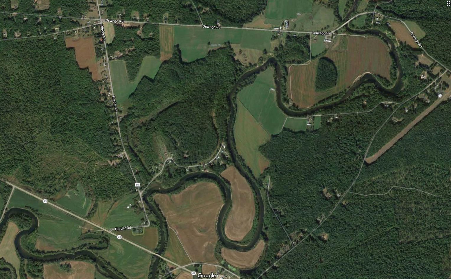
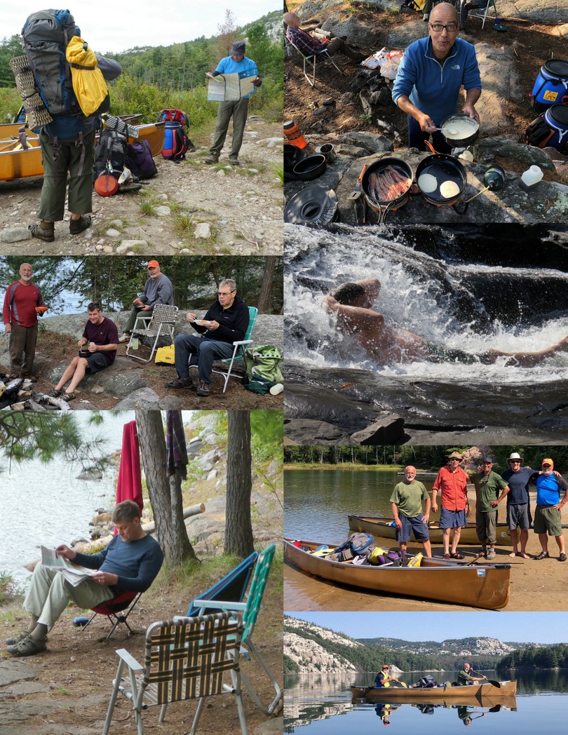
Sunday – 6am and I am in Skip’s driveway and he is in mine as we got mixed up on our departure. A quick phone call and we got straightened out and headed north on Route 12. We had 9 hours of driving time and 11 hours total travel time including lunch and meeting at Walmart, to get to Killarney Outfitters. Conrad and Jack rented a canoe and accessories. We finally found a place open to give us dinner and returned to squeeze 4 tents into our small site; so snoring was an issue.

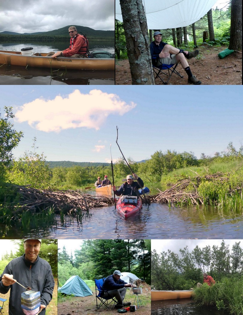
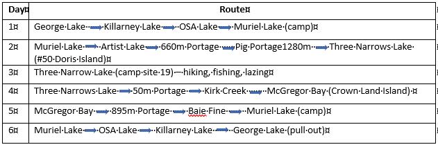
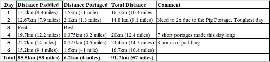
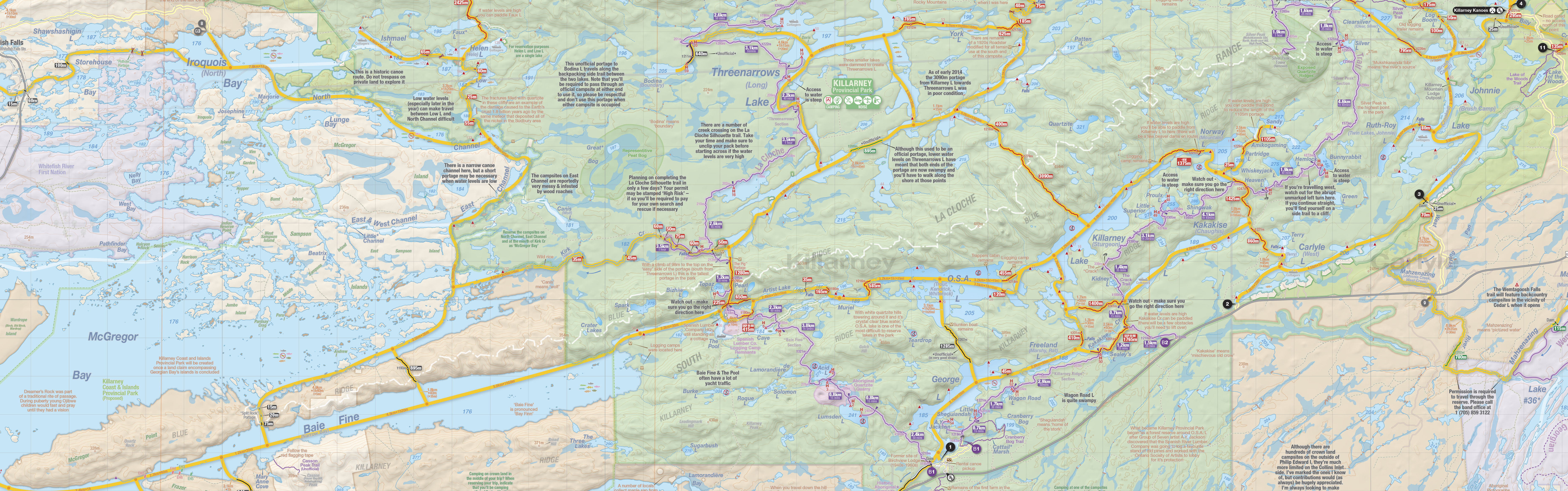
Monday- We sorted out our gear and got packed.  We were on the water at 0945.  There was over a mile (1.6 km) over 4 portages.  After the 1st couple I got more organized and carried two packs and the lawn chair then doubled back for the canoe.  We stayed at Muriel Lake for night 1.   Steve thawed his beef stew only to discover it was Skip’s chili.  We were lucky to avoid the rain or high winds which predicted in the forecast. However, it remained cloudy and the temperature dropped at 0600. Skip’s chili dinner was good.  During the night Skip awoke from a dream convinced a bear had taken down out hung food.  He yelled ‘There’s a bear getting our food’ and got everyone to go look.  Of course, there was no bear and the food was fine.

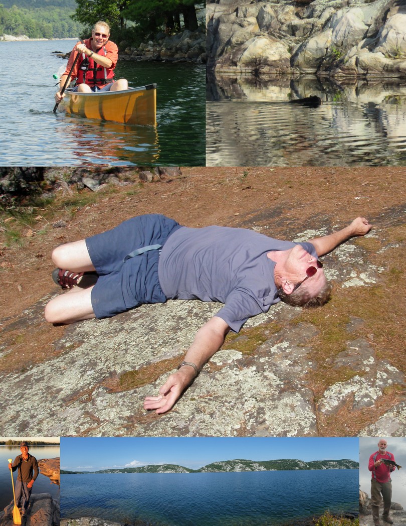
Tuesday – After a leisurely breakfast we were on the water by 0930. We had difficulty finding the 1st portage and portaged into a weed choked Artist Lake.  The day was dominated by “The Pig” a 3 hour portage with 1,000 meter elevation gain. It was a rough portage with lots of cobblestones; fortunately the stream bed was dry.  Conrad and Jack took a side trail to Topaz Lake and enjoyed lunch and a swim. We got off The Pig at 3pm and spent two hours paddling for a campsite, ending up on Site #50 Doris Island.  We all did a swim before dinner washing off the day’s sweat.  We had Steve’s beef stew for dinner.  We turned in at 8pm.  I read for 1 hour and slept the night. I heard a lot of Barred Owls during the night.

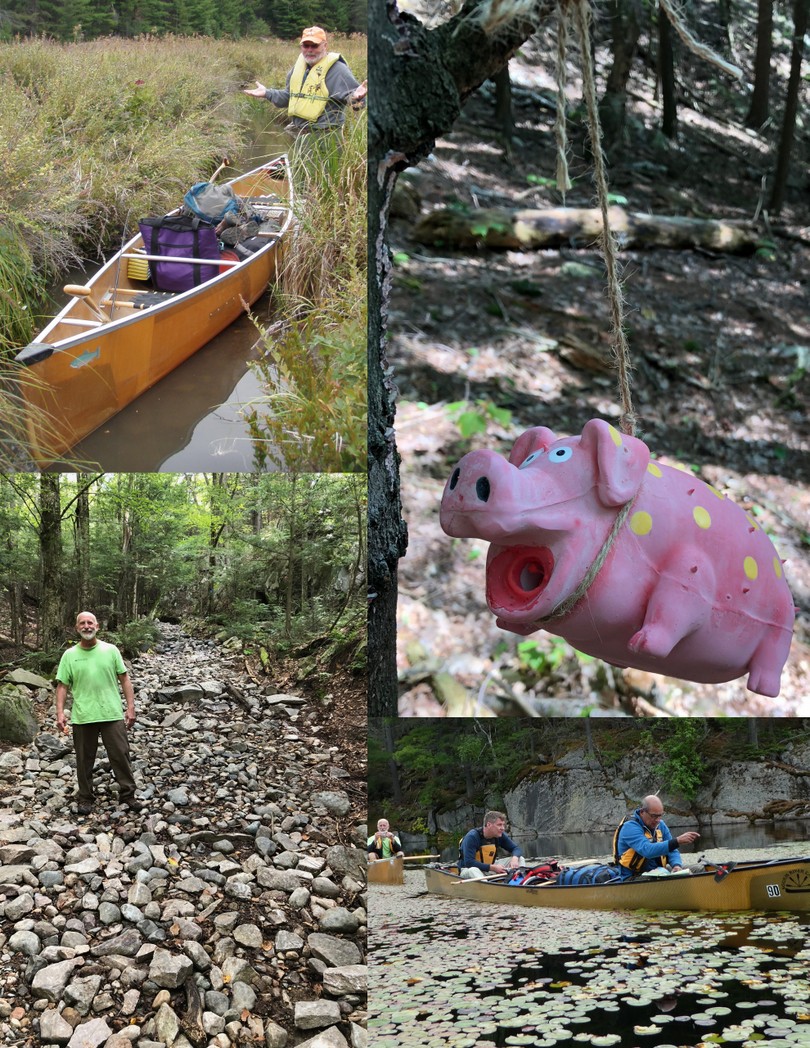
Wednesday – This was our lazy days.  Conrad and Jack took a hike while Steve fished, and Jim & Skip read.  Conrad made pancakes and pre-cooked bacon for breakfast.  We saw a black bear swim from our island across a span to opposite shore.  Conrad had packed a small box of wine in the food barrel which sprung a leak during the Pig portage.  The only food affected was the boxed spaghetti, but the accident necessitated a through cleaning of the food barrel.  Spaghetti dinner was moved up in the order of meals and greatly enjoyed.

Thursday – We were on the water at 9am and paddled back across three Narrows Lake past The Pig, hit seven small portages along Kirk Creek to come out onto Georgian Bay.  We decided to skip site #137 and paddle another 45 minutes to  camp on Crown Islands.  Total paddle time from 9am to 3:30!  Dinner was that San Francisco treat; Rice a Roni supplemented with additional rehydrated vegetables and hamburger.

Friday – Rather than take the 800’ elevation gain portaging over the Baie Finn we opted for the Split Rock portage.  We paddled continuously from 0830 – 0430. – 8 hours! Our campsite on Muriel was the best swimming site I’ve used.  We were all tired.  We did stop a couple of times (Jeff’s Point) to stretch, snack and drink.  I went through a gallon of water during the day.  Dinner was rice and Indian spices.

The portage song…. Sung to “Itsy Bitsy Spider”
Itsy Bitsy portage, everyone get out.
To carry all this stuff you must be strong and stout.
Follow the trail with all its twists and bends;
because itsy bitsy portage, it will never end.

Whether it was the location, the food, the sensory overload several members of our group experienced hallucinations.  In addition to Skip’s Bear Dream, Steven was convinced there was a kayak fisherman anchored across the bay who was fishing a prime location.  In fact, Steve was certain he saw him pull in a fish.  View from another vantage point the kayak fisherman turned out to be a rock cairn piled on a small ledge.  Paddling out across Three Narrows Lake on Day 4 Conrad alerted the group to witness a mother loon and her chick sitting on a rock just ahead of us.  Upon closer inspection, the “loons” turned out to be two proportionately sized rocks.

Sung to “Somewhere Over The Rainbow”
Somewhere in park Killarney, there we’ll be;
‘Cause in park Killarney hallucinations you’ll see.

There’s a kayak fisherman, I cannot see him, but Steven can,
Oh Killarney!
A mother loon and her first child, they do not move, don’t look too wild
Oh Killarney!
Skip is sure he saw a bear, but when we looked there’s nothing there.
Oh Killarney!

Somewhere in park Killarney, there we’ll be;
‘Cause in park Killarney hallucinations you’ll see.

Best things about the trip:

  • The company. It was with trepidation that we joined an established group with the unknowns of group dynamics, leadership styles, food tastes, camp protocol, paddling speeds and sense of humor.  Despite long days and occasionally arduous conditions we operated well.
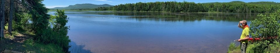
  • Awesome weather that allowed us to enjoy our surroundings.  We covered some big, open water that could have been dangerous in windy conditions.
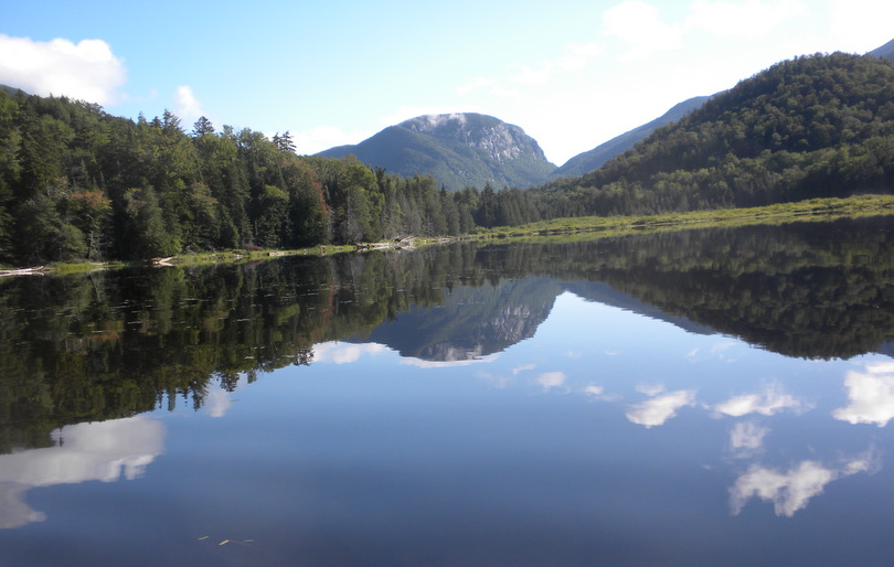
  • Fantastic landscape with white granite cliffs at the shoreline.
  • Clean accommodating campsites.
  • We did it and survived to tell about it.  Although everyone suffered aches and pains along the way.

Return to Moshier

Eric spent the night at BillieJo’s playing video games with Stone while Kathryn, Skip, Matt, Nathan and I camped overnight at Moshier Reservoir.  The fishing wasn’t quite as good, but the company and weather were superb.  We heard lots of Barred Owls during the night and managed to sleep for almost 11 hours.

Paddling up the Kunjamuk with Matt and Chris

Matt wanted to paddle the Kunjamuk and show it to Chris, so we set out at 10am on a perfect day.  We have made this trip many times before but this was the 1st time we stopped and hiked to see the famous Kunjamuk Cave.

The water level was slightly lower than when we had paddled the Kunjamuk with the Helmers a few weeks prior.  We paddled up the the southern tip of Elm Lake.

Fish Creek

Skip, Don and I did a day trip on the lower 9 miles of Fish Creek from the Oswego Road Bridge to the Ta-Ga-Soke Campground in Sylvan Beach.

The lower sections of Fish Creek is meandering flat water as evident from the image below.  From the Oswego Road bridge to the Route 49 Bridge was ~4 miles with a few small riffles to pick through and strainers to avoid. It was 5 miles further to the take out in Sylvan Beach

The put-in at Oswego Road bridge has a small parking lot – mainly for local fishing access.  It is a short portage cutting the corner of a corn field and a small steep bank that leads to a launch site.

Most of the section from Oswego Rd to Rt 49 bridge is a winding channel surrounded by high dirt banks and lined by eroded trees – forming strainers.  We probably saw half dozen trees broken off into the creek from the thunderstorm the prior night. The high water levels resulting from spring run-off and ice jam flooding is evident throughout.  Due to the dirt banks there weren’t many places to pull out, shade up and stretch our legs. It took us a little over an hour to paddle to the Route 49 bridge where one could hydrate, snack and stretch.

We were paddling a fiberglass Wenonah Jensen 18 and a solo Nova Craft Trapper.

The lower section of Fish Creek from the Route 49 bridge to the take-out was broad, flat and subject to wind.

We wanted to avoid Sylvan Beach and the boat traffic leading to Oneida Lake so we scouted potential take out sites near the Ta-Ga-Soke Campground.  The campground manager gave us permission to leave a shuttle vehicle at their driving range and use the adjoining hay field for our take-out.  Getting from creek level to the field required a scramble up a 12 foot dirt bank, but there weren’t a lot of options.

Overnight on Cedar River Flow

Matt, Skip, Steve and I took an overnight canoe camping trip to Cedar River Flow on Sunday – Monday.  The threat of rain and beginning of the work week combined such that we only saw one other canoe as we paddled in on Sunday afternoon.  The black flies swarmed us as we loaded our boats so we sought a campsite with lots of exposure to wind.  We lucked out with the weather with only slight showers and no rain while we set up camp and cooked dinner.

Deluxe Yoke Pads for Wenonah Cascade Canoe

After our last trip down the Hudson River it was agreed that not only was the Wenonah Cascade Royalex canoe heavy, but it was made worse by a plain ash yoke that offered no relief when portaging.  Today I installed deluxe yoke pads purchased from Bourquin.  A short walk around the yard felt improved, but a serious portage is needed to test them out.  They will probably stretch or change the placement of the canoe cover as well.

Hudson River

Skip and I planned an overnight trip down the Hudson River from Harris Lake, Newcomb to the Gooley Club take out neat Indian Lake a distance of about 14 miles encompassing several Class II and III rapids.  There are two designated two takeouts. The first is 7.3 miles from the launch at a steel bridge (just below the confluence with the Goodnow River). The second is six miles farther downstream, at the confluence with the Indian River.  There is a designated camp site at the confluence with the Cedar River.

There are two designated two takeouts. The first is 7.3 miles from the launch at a steel bridge (just below the confluence with the Goodnow River). The second is six miles farther downstream, at the confluence with the Indian River.  There is a designated camp site at the confluence with the Cedar River.

After dropping off our shuttle vehicle at the Gooley Club take-out we launched from Harris Lake at 1100 under perfect weather conditions.  We were hoping for water levels at or slightly above the 3 foot mark, but began the trip at 2.8′ and ended up at 2.6′.  Depending on the water level, the white water  can range from nearly Class III rapids to rocky riverbeds that require lining.  In total there were about a dozen rapids of various difficulties.

We ran the Long Falls easily, but spent and hour scouting and portaging the .5 miles around Ord Falls.  The remainder of the 7 or so rapids we were able to comfortably run with only glancing rock encounters.  After four hours and ~7 miles we pulled out at the Polaris Club (aka Iron) Bridge. This site provides a hand launch site just downstream of the bridge and is reached via a 0.3-mile carry from the Polaris Bridge Parking Area located along Drakes Mill Road off the Chain Lakes Road North. The bridge and the roads on either side of it serve as the northern boundary of the Hudson Gorge Wilderness on the western bank and the Hudson Gorge Primitive Area on the eastern bank. The bridge is located just downstream of the confluence of the Goodnow River (43.8952°N, 74.1690°W) Google Maps

We wanted to camp at the confluence of the Cedar River which we estimated would entail another 2 hours of travel.  What we didn’t anticipate was the effort in portaging around the old log dam a few miles downstream from the bridge.  We exited river right but didn’t find a carry trail and spent another hour exiting, scouting and carrying our canoe and gear.  Below the dam we lined our boat further downstream until we could achieve a clear line of passage. Surprisingly quick it seemed we were at the Cedar River campsite. The Cedar River campsite is located immediately below the Cedar River on the river right (western) bank of the river. (43.8522°N, 74.1894°W) indicated on maps as being on the point at the confluence of the Cedar River.  This was a nice campsite, but the steep banks and fast current made the landing and exiting of our canoe challenging.  Adding to the drama was a set of rapids which motivated one to not miss exiting.

Two miles downstream from the confluence of the Cedar River and eight miles downstream of the Polaris Bridge is the Hudson River Take-out, located 0.2 mile upstream of the confluence of Indian River. The final take out is located on the right side of a sharp bend of the Hudson River just before he confluence of the Indian River.  The metal roof of the Old Gooley Farmhouse (43.8275°N, 74.2008°W) Google Maps may be visible from the Hudson River.  Portage is up the hill through the field.  A 2nd ‘official’ portage is located a few hundred feet downstream and marked with a sign, however, the sign may be obscured by vegetation.  The river at the take out is deep and the trail up requires climbing some steep ledges. Parking at the ‘official’ take out is limited to one vehicle. Shown below left is the confluence of the Cedar River and the Gooley Club take out site just north of the confluence of the Indian River.  The image on the right provides a close up of the Gooley Club take out.


We were hoping for water levels at or slightly above the 3 foot mark, but began the trip at 2.8′ and ended up at 2.6′.  Depending on the water level, the white water  can range from nearly Class III rapids to rocky riverbeds that require lining.  In total there were about a dozen rapids of various difficulties.

Henderson Lake and Scouting the Hudson

Skip and I took a short camping trip on Henderson Lake.  We were looking for a previously unmarked campsite (site 3) which was easily found now that it is marked, but it was wet, sloping and not very attractive.  We ended up staying in the lean-to, which worked out to our advantage as the day had intermittent showers.  It cooled off over night but there were still a few mosquitoes in the evening, so we went to sleep wearing head nets.

The view from Henderson.

We were up early and left Henderson by 9am.  On our way out we passed several hikers headed to summit Mt Marcy, including one young girl hiking solo with new boots.  She said she had no hiking experience, but wanted to accomplish something similar to her friends that lived in Colorado and did frequent hiking.  I wonder how her day turned out.

We left a parking lot filling with day paddlers and more hikers to scout the upper Hudson River – particularly the Blackwell Stillwater section.  After a a long drive into the Polaris Bridge we re-considered, as our shuttle vehicle was not equipped to carry a canoe.  Poor planning on our part.  So we scouted the Hudson River with an intent to plan an overnight trip in September.  We checked out the put-in, Polaris Bridge, the Deerland lean-tos, and the take out for the Hudson on the Gooley Club road.  We planned to hike into Sprague Pond for an overnight but were unable to find the trailhead based on the scant information we had.  In review we were probably at the right location, but deterred by posted signs. friends that lived in Colorado and did frequent hiking.  I wonder how her day turned out.

We made a stop at the lake, and all in all it was pretty fun. We’re a bit more into hiking, but in doing so we sometimes pass a few places too good not to stop for a while at. There were plenty of nice places set up around the lake. I saw a resort with entertainment, a couple of seafood restaurants, and a few places to buy fishing gear. They also had plenty of watercraft there to rent and we found the price pretty reasonable, so we took a couple jetskis for a spin. We don’t get to do that very often in our travels. It was a nice break from the trail for sure.

We left a parking lot filling with day paddlers and more hikers to scout the upper Hudson River – particularly the Blackwell Stillwater section.  After a a long drive into the Polaris Bridge we re-considered, as our shuttle vehicle was not equipped to carry a canoe.  Poor planning on our part.  So we scouted the Hudson River with an intent to plan an overnight trip in September.  We checked out the put-in, Polaris Bridge, the Deerland lean-tos, and the take out for the Hudson on the Gooley Club road.  We planned to hike into Sprague Pond for an overnight but were unable to find the trailhead based on the scant information we had.  In review we were probably at the right location, but deterred by posted signs.

St Regis Lakes

Exploring the Upper St. Regis Lake, Spitfire Lake, and Lower St. Regis Lake Lakes provides views of historic Great Camps. These lakes are connected by wide channels. These are a large lakes vulnerable to weather, which can create choppy water. Three accessible boat launches and one carry that is only .6 miles long adds up to a classic loop.

Launching Points:

  • Keese Mills Road Latitude: 44.43212271 Longitude: -74.29987192
  • Paul Smith College Latitude: 44.4339341205 Longitude: -74.2532661930
  • Upper St Regis Lake Boat Launch Latitude: 44.3949091528 Longitude: -74.2698393948. Access to Upper St. Regis Lake is from a small town launch at Upper St. Regis Landing, just off Route 30, between Paul Smiths and Lake Clear, off St. Regis Carry Road.

Upper St. Regis Lake along with Lower St. Regis Lake and Spitfire Lake, became famous in the late 19th century as a summer playground of America’s power elite, drawn to the area by its scenic beauty and by the rustic charms of Paul Smith’s Hotel. It is the site of many grand old summer “cottages” and Great Camps. Upper Saint Regis Lake is part of the original Seven Carries canoe route from Paul Smith’s Hotel to Saranac Inn. Upper St Regis Lake consists of connected water bodies full of historic great camps and boathouses that make for a great tour. The lake is 742 acres in size. Average depth is 25 feet with a maximum depth of 90 feet.

Skip and I drove up in the morning and launched from the Upper Regis Landing about 11am.  We proceeded north along the western shore and stopped at a small waterfall coming out of Spectacle Ponds.  Walking along the stream we saw stone carvings and a tribute to George Francis Raymond. A search discovered his obituary but no described connection to the Adirondacks.

We continued north and began what we thought was a short portage leading to Black Pond. However, after a portage and hike of a mile we decided to return and approach Black Pond from  Lower St Regis Lake.  We continued our clockwise tour of Upper St Regis Lake, sticking close to the shoreline  as the wind was causing breaking white caps on the lake.  Somehow we missed the access to Spitfire Lake and made a complete loop back to the boat launch.  We decided to use the access to the St Regis Canoe area and portaged to Mud and Bear Ponds looking for a suitable campsite.  As shown by the picture below the water levels were unusually high due to the frequent rains this summer.  Our search for a dry and bug free campsite was not successful so we decided to return to the truck and camp in one of the Floodwood campsites for the night. We stayed at site #3, set up our tents, relaxed and read, and had a dinner of hot dogs, beans, bagel, fruit cup and Oreos.

The next day we found the boat launch at Paul Smith’s College.  The 350-acre Lower St. Regis Lake has as its northern edge Paul Smith’s College, There’s five miles of shoreline to explore around this lake. The narrows that access the lake offer scenic paddling in the region and are a destination themselves. There are several dirt floor lean-tos scattered along the shoreline.  There is a trail to St. Regis Mountain provides a view with only a moderate climb, however we did not choose to hike.

We paddled from Paul Smith’s to the outlet dam and examined several available lean-tos along the way; most had dirt floors.  On our return we visited Peter’s Rock which had a huge sloping rock to the water and a fine lean-to.

Upon our return we will paddle Spitfire Lake.