Tag Archives: camping

Winter Camping at Burbine

It has been a few years since I have been winter camping. I met Matt for an overnight camping at Thomas Burbine Memorial Forest which houses a disc golf course, nature trail, fishing pond and a lean-to. It was a short and easy hike to the lean-to as we dragged our sleds filled with camping gear and firewood. Matt and I had camped here at in March of 2020 at the outbreak of COVID. During that visit the lean-to was plagued by mice – which annoyed Matt as he stayed in the lean-to but were just noises to me as the mice scuffled in the leaves. After a brief inspection we declared the lean-to to be mouse free. Staying in the lean-to made life easier as it provided seating and made packing up in the morning much more convenient. Overnight temperatures were in the high twenties and we received a slight snowfall – just enough to make sliding the sleds out easier and reveal the deer and fox prints made that morning.

The day after this popped in my head:

No hooting owl
Or coyote’s howl
No breeze across my face.

A day’s gone by
I don’t know why
I find I still think of that place.


Lake Kushaqua – Rainbow Lake

Took a nice 3 day trip starting at Lake Kushaqua. Lake Kushaqua is a 380 acres lake near Loon Lake and Rainbow Lake in the town of Franklin, It is on the North Branch of the Saranac River. The shoreline is state owned except for two small in-holdings.

We paddled to Clear Pond (~5 miles). Clear Pond parallels the three-mile long narrow Rainbow Lake, separated from it by a narrow esker. Day 2 we paddled empty canoes from Rainbow Lake to Jones Pond and Osgood Pond and then returned to our Clear pond campsite. The round trip distance is about 12 miles with a 1.5 mile carry between Rainbow Lake and Jones Pond. That took us about 6 hours, which is more than I really want to be paddling anymore.We caught a break with the weather in that we only experienced rain on Tuesday morning; so we sat under a tarp and had a leisurely breakfast. Day 3 we paddled out.

Stillwater Campsites 39-46

Skip and I made a 3 day/ 2 night trip to Stillwater specifically to scout the conditions of campsites 39 – 46. We utilized the water access off Moose Road and had a short paddle to site 41 where we set up out base camp. The 1st day we were hampered by high winds and merely relaxed in camp. The following day we located and inspected each campsite with an eye towards future use.

Overnight Camping at Thomas H Burbine Forest

Burbine Forest (42.81569, -74.38742) is approximately 330-acres located on Pond Road, just off of Corbin Hill Road, Sprakers in the township of Charleston. During the great depression, many farmlands were abandoned and reverted back to state ownership.  Often these lands were reforested by the Civilian Conservation Corps and are now state forests. In 1930, Montgomery County purchased the piece of land from the Fort Plain Bank to create a County forest. The forest contains numerous tree species such as oaks, maples and pines, ample wildlife and a wetland. Thomas H. Burbine Nature Loop is a 1 mile loop trail located that features beautiful wild flowers and is good for all skill levels. The trail portion was partially created as an Eagle Scout project.

With everyone locked down due to the Corona virus and clear weather with temperatures in the high 30s; Matt and Jim visited the forest and camped overnight. During the night we were visited by loudest Barred Owl I have ever heard. He must have been in the trees just above our tents. Temperatures overnight dropped to 18 degrees and created frost everywhere. We arose at 6:30am, packed up and headed home.

Kathryn’s 2nd Solo Canoe Camping Trip

Kathryn completed her second-ever Solo (+dog) canoe camping trip. Positioning a 100lb dog can make one a little nervous especially if she won’t lay down in the canoe, but other than that she was a perfect companion for 24 hours of wilderness and quiet. Kathryn had a fabulous time and pledges to do this more often. Jim and Eric came up today for lunch and escorted us back.

Little Tupper Lake to Lake Lila to Lows Lake

In 2002 Kathryn, Matt, Mark and I did an overnight trip from Little Tupper Lake to Lake Lila shortly after NYS acquisition of the Whitney Estate. At the time we were told that less than 75 people had completed the trip. For this adventure trip we planned to continue past Lake Lila and portage to Lows Lake per the schematic below.

It was a 2 hour drive from Floyd to the Little Tupper Lake boat launch off Sabattis Road in the town of Long Lake. We met Steve at the launch about 9am and unload everything from the truck for Skip and Paul to guard while Steve and I transferred my truck to a parking spot in the Lows Lake parking lot. We returned in Steve’s car to LTL boat launch and were paddling by 11am. We headed to Rock Pond to find a campsite for the night.

Rock Pond to Lows Lake Traverse

Little Tupper is six miles long and at 2,300 acres, it is the 14th biggest lake in the Adirondack Park. Behind Lows Lake, it is the second biggest motor-free lake. There are 24 designated primitive paddle-in campsites available on a first-come, first-served basis. To the west is a low wetland and the outlet of Charley Pond. We paddled upstream towards Charley Pond as far as the Burn Road Trail bridge. One can continue paddling further upstream for ~mile before reaching private land.

The Rock Pond Outlet is 1.5 miles of fairly wide, gently-winding stream with boggy shores. Rock Pond has a total of six campsites. We stopped at the 1st available for a late lunch at 2:30. We debated the merits of staying on Rock Pond versus trying to knock off the 2 mile portage to Hardigan Pond and staying at the unknown campsite. The Rock Pond campsite won the debate. While snacking we saw people at site 26 – the island campsite. We decided to scout the other campsites and discovered the two people on the island site were day tripping and returning to Little Tupper Lake. We set up camp and the light breezes kept the bugs away.

Looking at Salmon Mtn from Rock Pond

Day 2 we got up at 5:30am and were on the water by 7:30 as we had 4 miles of portages to accomplish to reach Lake Lila. We started off with a 2 mile portage to Hardigan Pond. From Hardigan Pond there was a .55 mile portage to Salmon Lake Outlet. From Little Salmon Lake there was another .5 mile portage into Lilypad Pond. Each of these portages included traipsing over beaver dams or flooded trailways resulting in soaked feet. Finally we concluded an .8 mile portage from Lilypad Pond to Shingle Shanty Brook. We paddled the meandering Shingle Shanty Brook for nearly 45 minutes until reaching Lake Lila. While all these portages showed footprints, the trails were overgrown with ferns and briars. The deer flies were a constant annoyance. While we tried to single carry portions of the portages, largely we leap-frogged our packs and the canoes. White caps were rolling on Lake Lila so we undertook tacking maneuvers to quarter the wind and stay near shore. We reached site 20 which was a large open site with a rocky beach. We went swimming, re-hydrated and cooked dinner. We set up a tarp due to rain projected in the forecast.

We awoke at 6am with the sound of light rain and packed up our damp tents during a lull in the rain. On the water at 7:30am we set off for the Harrington Brook trailhead. The Harrington Brook trail was extremely muddy so we opted to make the short bushwhack to the railroad tracks and skip the Harrington Brook trail and pond. As we trekked up the 1.2 miles up the railroad tracks the rain transitioned from light sprinkles to an absolute downpour as we launched into Clear Pond. The portage from the railroad to Clear Pond was open with good footing – the best trail of all the portages. The deer flies at Clear Pond and Bog Lake were horrendous – causing us to paddle with head nets.

Lows Lake

Paul and I made a navigation error and prolonged our trip on Lows Lake; otherwise extending a 15 mile paddle. As the rain continued we decided to paddle out to the lower dam and head for home, rather than set up a campsite and leave the next morning. We were loaded up by 8:30pm (making a 13 hour day) and drove home to showers and dry clothes.

Stillwater Reservoir

Skip and Steve left on Thursday to scout campsites; ending up at Picnic Point, which they said was fine when breezy, but overrun with mosquitoes when the wind died down. So they picked an alternative (#37) for those of us that arrived on Friday. There were a couple of very nice rv parks nearby, probably due to this lovely location, so we decided to take ours there. Then Kathryn, Gaie and I paddled in Friday afternoon, followed by Dave and Debbie Shoemaker. I’ve always thought this is one of those great family activities for when you want to outdoors, have fun, and get some fresh air.

After sitting up camp Kathryn and Gaie went fishing with Kathryn catching 7 small bass during the evening session.

Kathryn made Spanish Rice for dinner which was delicious and bountiful. It rained overnight but cleared out Saturday morning. We took the canoes out for fishing, but didn’t have much luck. The weather was highly variable with sun, clouds and wind all fluctuating throughout the day, but no rain. At night we had chicken and rice with vegetables. After dinner and another attempt at fishing the crew started playing pitch and looking over their shoulders at a pending thunderstorm. We settled until Skip’s tarp just as the heavens unleashed a torrential rain. It rained almost all night. Sunday morning we awoke at 6, packed up our gear, were on the water a little before 9am and off the water 45 minutes later.

Killarney Provincial Park

Sunday – 6am and I am in Skip’s driveway and he is in mine as we got mixed up on our departure. A quick phone call and we got straightened out and headed north on Route 12. We had 9 hours of driving time and 11 hours total travel time including lunch and meeting at Walmart, to get to Killarney Outfitters. Conrad and Jack rented a canoe and accessories. We finally found a place open to give us dinner and returned to squeeze 4 tents into our small site; so snoring was an issue.

Monday- We sorted out our gear and got packed.  We were on the water at 0945.  There was over a mile (1.6 km) over 4 portages.  After the 1st couple I got more organized and carried two packs and the lawn chair then doubled back for the canoe.  We stayed at Muriel Lake for night 1.   Steve thawed his beef stew only to discover it was Skip’s chili.  We were lucky to avoid the rain or high winds which predicted in the forecast. However, it remained cloudy and the temperature dropped at 0600. Skip’s chili dinner was good.  During the night Skip awoke from a dream convinced a bear had taken down out hung food.  He yelled ‘There’s a bear getting our food’ and got everyone to go look.  Of course, there was no bear and the food was fine.

Tuesday – After a leisurely breakfast we were on the water by 0930. We had difficulty finding the 1st portage and portaged into a weed choked Artist Lake.  The day was dominated by “The Pig” a 3 hour portage with 1,000 meter elevation gain. It was a rough portage with lots of cobblestones; fortunately the stream bed was dry.  Conrad and Jack took a side trail to Topaz Lake and enjoyed lunch and a swim. We got off The Pig at 3pm and spent two hours paddling for a campsite, ending up on Site #50 Doris Island.  We all did a swim before dinner washing off the day’s sweat.  We had Steve’s beef stew for dinner.  We turned in at 8pm.  I read for 1 hour and slept the night. I heard a lot of Barred Owls during the night.

Wednesday – This was our lazy days.  Conrad and Jack took a hike while Steve fished, and Jim & Skip read.  Conrad made pancakes and pre-cooked bacon for breakfast.  We saw a black bear swim from our island across a span to opposite shore.  Conrad had packed a small box of wine in the food barrel which sprung a leak during the Pig portage.  The only food affected was the boxed spaghetti, but the accident necessitated a through cleaning of the food barrel.  Spaghetti dinner was moved up in the order of meals and greatly enjoyed.

Thursday – We were on the water at 9am and paddled back across three Narrows Lake past The Pig, hit seven small portages along Kirk Creek to come out onto Georgian Bay.  We decided to skip site #137 and paddle another 45 minutes to  camp on Crown Islands.  Total paddle time from 9am to 3:30!  Dinner was that San Francisco treat; Rice a Roni supplemented with additional rehydrated vegetables and hamburger.

Friday – Rather than take the 800’ elevation gain portaging over the Baie Finn we opted for the Split Rock portage.  We paddled continuously from 0830 – 0430. – 8 hours! Our campsite on Muriel was the best swimming site I’ve used.  We were all tired.  We did stop a couple of times (Jeff’s Point) to stretch, snack and drink.  I went through a gallon of water during the day.  Dinner was rice and Indian spices.

The portage song…. Sung to “Itsy Bitsy Spider”
Itsy Bitsy portage, everyone get out.
To carry all this stuff you must be strong and stout.
Follow the trail with all its twists and bends;
because itsy bitsy portage, it will never end.

Whether it was the location, the food, the sensory overload several members of our group experienced hallucinations.  In addition to Skip’s Bear Dream, Steven was convinced there was a kayak fisherman anchored across the bay who was fishing a prime location.  In fact, Steve was certain he saw him pull in a fish.  View from another vantage point the kayak fisherman turned out to be a rock cairn piled on a small ledge.  Paddling out across Three Narrows Lake on Day 4 Conrad alerted the group to witness a mother loon and her chick sitting on a rock just ahead of us.  Upon closer inspection, the “loons” turned out to be two proportionately sized rocks.

Sung to “Somewhere Over The Rainbow”
Somewhere in park Killarney, there we’ll be;
‘Cause in park Killarney hallucinations you’ll see.

There’s a kayak fisherman, I cannot see him, but Steven can,
Oh Killarney!
A mother loon and her first child, they do not move, don’t look too wild
Oh Killarney!
Skip is sure he saw a bear, but when we looked there’s nothing there.
Oh Killarney!

Somewhere in park Killarney, there we’ll be;
‘Cause in park Killarney hallucinations you’ll see.

Best things about the trip:

  • The company. It was with trepidation that we joined an established group with the unknowns of group dynamics, leadership styles, food tastes, camp protocol, paddling speeds and sense of humor.  Despite long days and occasionally arduous conditions we operated well.
  • Awesome weather that allowed us to enjoy our surroundings.  We covered some big, open water that could have been dangerous in windy conditions.
  • Fantastic landscape with white granite cliffs at the shoreline.
  • Clean accommodating campsites.
  • We did it and survived to tell about it.  Although everyone suffered aches and pains along the way.

Camping Room

Our room over the garage was primarily used to store all our camping gear, hence the name “camping room”.  The room is a generous 14′ x25′ / 350 square feet, but unfinished.  We are insulating the ceiling of the garage and the floor of the camping room, but the walls were not insulated and the ceiling was left open.

The addition of a door, ceiling and insulation finished it off.  I bought a medium size electric heater and I spent two weekends priming and painting the room.  Today we moved most of the camping gear back into the room; still to come is additional furniture, about 6 sleeping pads and some backpacks/daypacks.

There is more organizing to be accomplished and I am trying to discard old and infrequently used gear as I go.  The plan is to leave room for cots / small bed to enable kids and guest an additional room to stay over during 3 seasons.

Jockeybush Lake

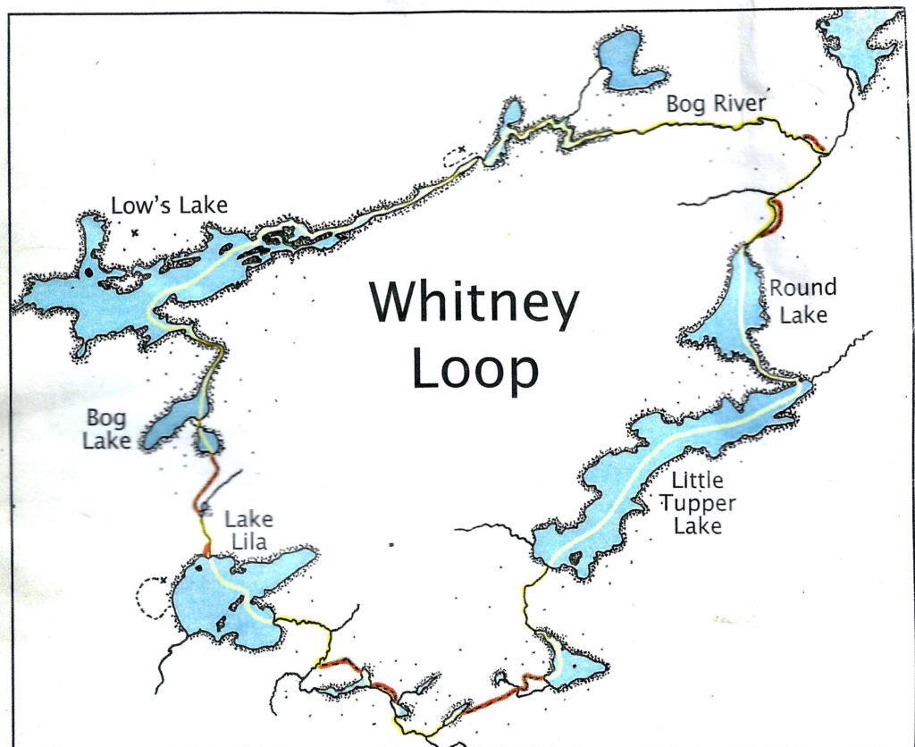
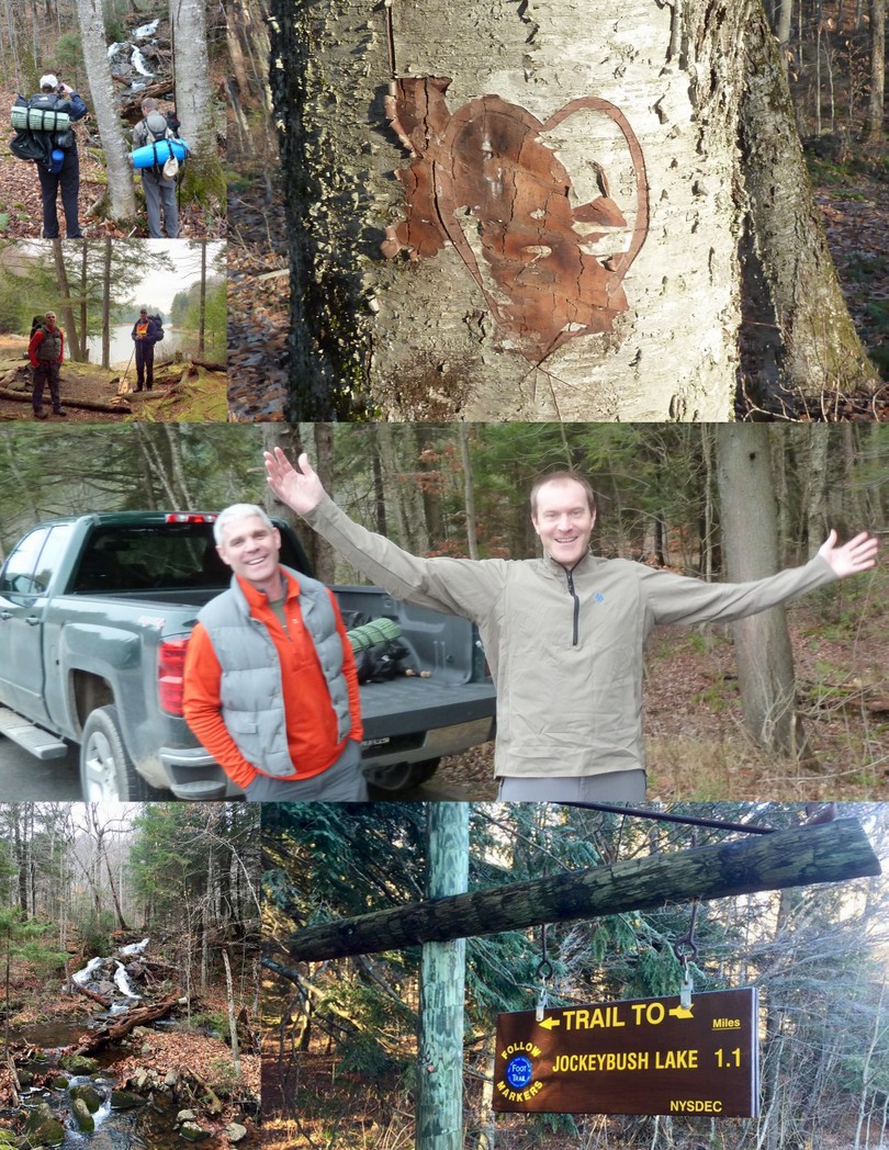
Matt, Mark, Rick and I were yearning for a trip in the woods and selected an easy trip into Jockeybush Lake for an overnight camping trip.  With temperatures in the mid-40s our hike was pleasant.  Jockeybush Lake is a 1.1 mile hike up a 200′ grade with two small stream crossings.   Access to the trail head  begins across from Lake Alma on Route 10 with parking is adjacent to yellow and brown trail sign. The trail follows a stream ith several small waterfalls that flows from the Jockeybush Lake into West Sacandaga River.

We celebrated seeing a Unicorn – Mark finally participating on a winter camping trip-  we took pictures of the waterfalls on our hike in, and observed a “Joanie loves Chachi” tree carving from a previous trip that went bad.

Hiking In

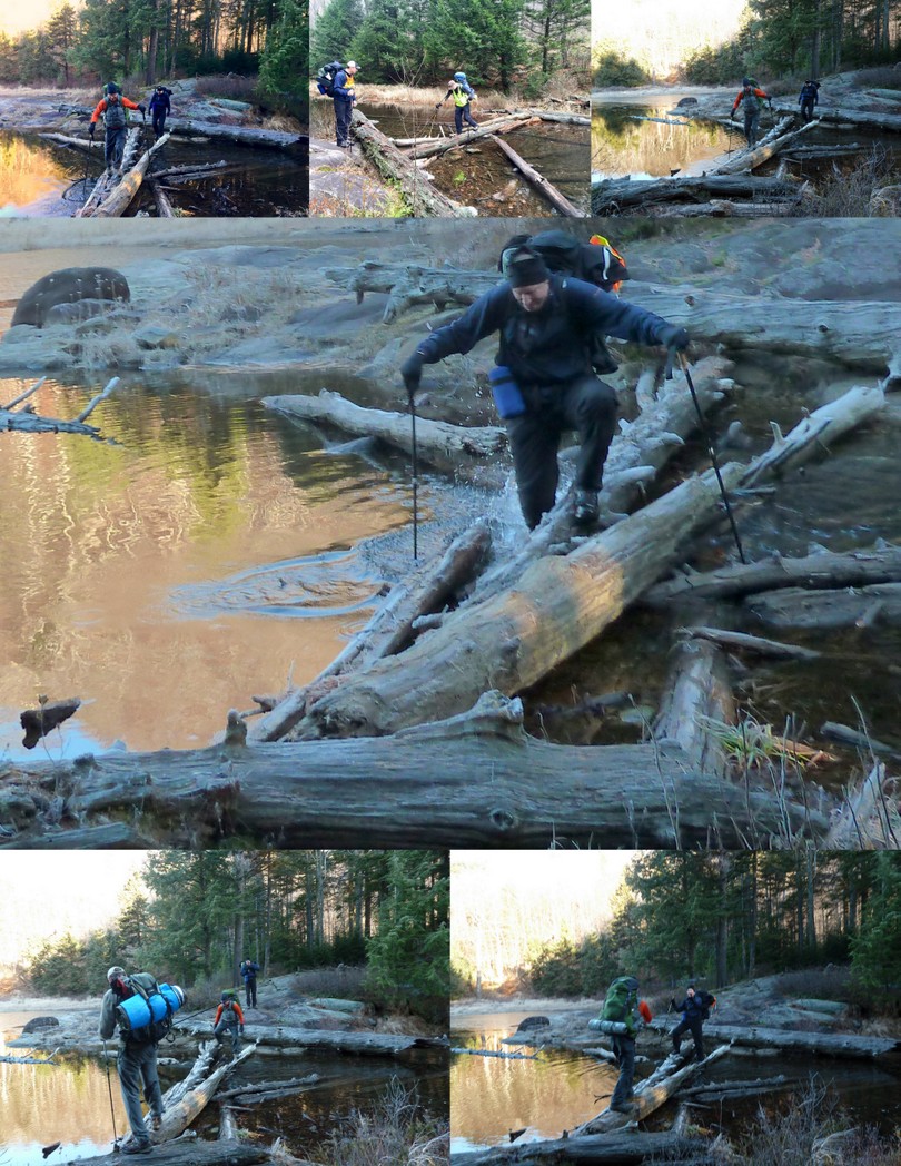
The south east end of the lake has a log jam across it, allowing one to cross to an area of large, flat rocks.  We used trekking poles for balance and safely crossed dry on the way in.  In the morning on the way out, however, it was a different matter.  The logs were covered with frost and slippery.  Matt got his boots wet at the start of the crossing and then plunged his foot into the water after slipping on the frosty log.

Log Crossing

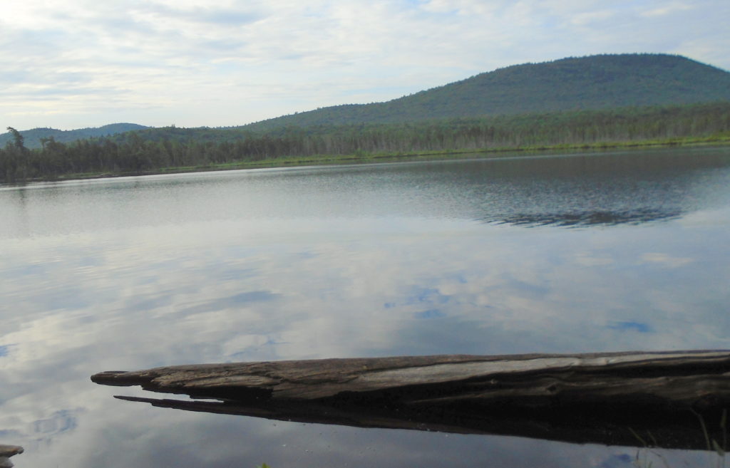
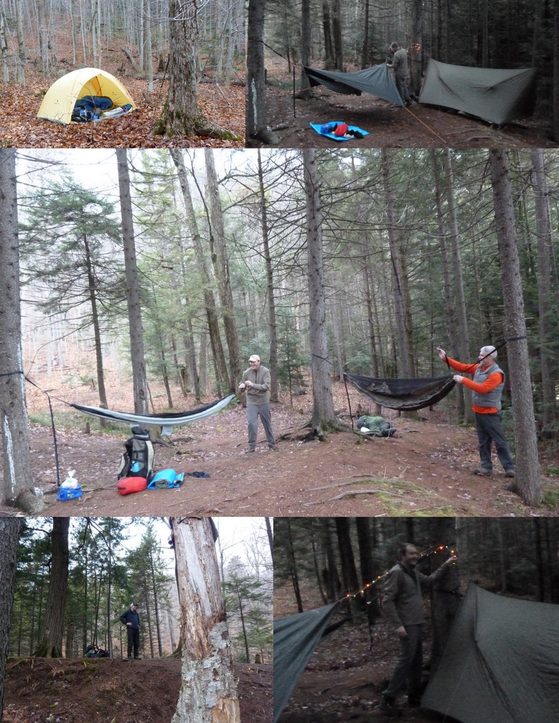
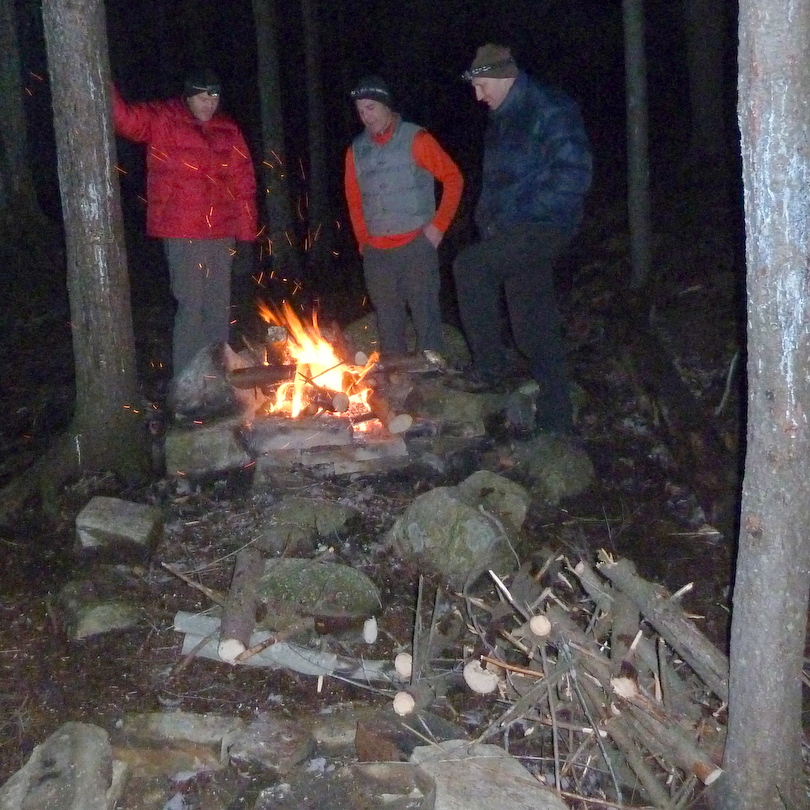
The view of the lake from this end is wonderful, however we found it devoid of wood and being cooled by winds sweeping down the lake. We followed an unmarked, but easy to follow trail around the north shore of the lake to another camp location where we deployed our various shelters.  I used my Black Diamond 1st Light tent, Matt used his tarptent and Mark and Rick used hammocks; Rick’s 4th attempt and Mark’s 1st use of a hammock for winter camping. Mark added a festive atmosphere by hanging holiday lights around his hammock.

Tenting at Jockeybush Lake

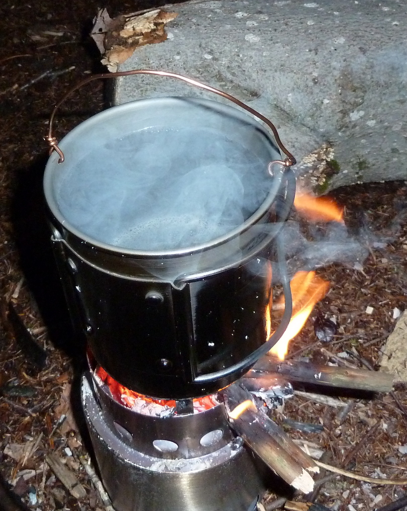
After setting up our tents we gathered firewood for cooking and an extended evening chatting around the fire; one of my favorite aspects of winter camping.  As the wind died down it actually felt a little warmer as the evening went on and we managed to stay up until 9pm before turning in.  Matt and Mark cooked brats on a stick over the open fire.  Rick used his alcohol stove to cook pasta and I boiled water from the lake over my Solo Stove.

P1060257

The solo stove consists of a main burn chamber, for burning the twigs, and a separate pot stand which a metal ring with three feet and a gap that lets you add twigs and small pieces of wood – roughly finger sized. Rising hot air pulls air through the bottom vent holes. This air movement fuels the fire at its base while also providing a boost of preheated air through the vent holes at the top of the burn chamber. The double wall Solo Stove is a natural convection inverted downgas gasifer stove. The air intake holes on the bottom of the stove channels air to the bottom of the fire while at the same time, channels warm air up between the walls of the stove. This preheated oxygen feeding back into the firebox through the smaller holes at the top of the stove causes a secondary combustion.  There is also a heat shield between the ash pan and the bottom of the stove which protects the ground under the stove from scorching.

This was my 1st time using the Solo Stove which I intended as a winter camping backup stove.  It worked well for one person, boiling 20 oz. of water for my freeze dried dinner in ~10 minutes.  It used 3-4 handfuls of twigs.  For an optimal burn it requires constant feeding, but it burned well with a mixture of dry and damp sticks.  The stove balanced well and I did not feel a need for a separate wind screen.  The usual issues with soot covering your pot exists – just like cooking over any wood fire.

P1060256

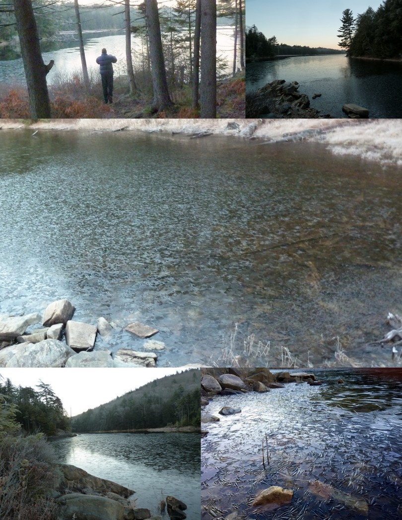
Overnight the temperatures dropped below freezing, causing the lake to freeze over with interesting ice patterns.

Frozen Lake

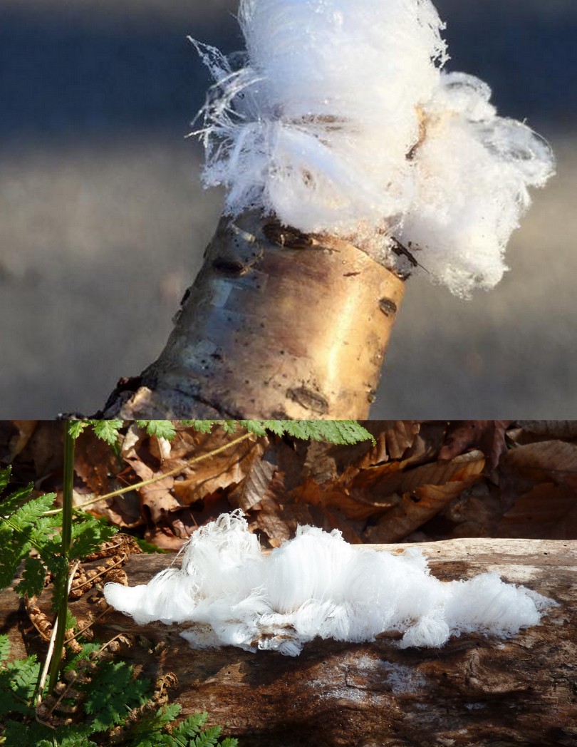
We encountered “Frost Flowers” on our hike out; something I had never seen before.  These are one of the stranger ice formations found in the woods; crystallofolia  are delicate ice formations that form from water emitted along a stem during a hard freeze in late fall/early winter. From Latin crystallus for ice and folium for leaf these are commonly called “frost flowers” or “feather frost”.

A typical example looks like a small puff-ball of cotton candy, a few inches across, made up of clusters of thin, curved ice filaments.   The petals of frost flowers are very delicate and will break when touched. They usually melt or sublimate when exposed to sunlight and are usually visible in the early morning or in shaded areas.

Frost flowers usually grow on a piece of water-logged wood.  It’s something of a rare find with conditions having to be just so before it will form. The formation of frost flowers is dependent on a freezing weather condition occurring when the ground is not already frozen. The moisture in the plants or dead wood expands when frozen, causing cracks to form in the stem. Water is then drawn through these cracks via capillary action and freezes upon contact with the air. The capillary action pulls moisture up from damp ground which continues to freeze and adds to what’s already frozen there. As more water is drawn through the cracks the thin ice filaments are essentially pushed out from pores in the wood as they freeze.

It’s something of a misnomer to call this frost since it freezes from liquid water, not water vapor. None the less, they were beautiful to see.

Frost Flowers